David Lieske discusses aging dikes, rising tides and climate change
The Tantramar dikes are beautiful components of Sackville’s landscape, but what is their importance? What do they do and how long will they last?
To learn about these structures, I turned to David Lieske, an associate professor in the department of geography and environment at Mt. A and the director of the Mt. A Geospatial Modelling Lab (GML). Lieske is a self-proclaimed “geospatial guy,” specializing in making maps and building models. His past research has delved into visualizing potential flooding of the dikes and surrounding marshlands as well as raising community awareness of potential risks.

“The dikes have been around for a long, long time,” Lieske said. “They go back to Acadian settlement times, to the first European settlement.” The dikes were constructed as an alternative to clearing forests, as this was less energy intensive. The Acadians had experience with dikes in France, which they brought with them to the north america. This led to agricultural advantages as well as changing ecosystems in the marshes.”
Acadian dikes are constructed from an aboiteau, “basically a box-like structure that was built originally through wood in an earthen embankment [with] a one way gate in,” said Lieske. “The Acadians built it with a wooden door. Nowadays we have steel doors and they’re bigger, but they’re basically the same principle. It’s kind of like your heart, it’s a one-way valve.” These aboiteaux allow fresh water to accumulate and salt water to be kept out as the gates are closed when tides rise in the Bay of Fundy.
However, not all dikes are constructed from these wooden boxes. In the 50s the federal government put forth a program called the Maritime Marsh Rehabilitation Act (MMRA). “The idea was to try to encourage the proliferation of agriculture so they identified our region in the Tantramar as being important,” said Lieske. “They invested a bit of money and they built that big, what I call, ‘super aboiteaux.’”
The “super aboiteaux,” a large green metal structure, can be seen on the way to Amherst. It is made up of two sixteen-foot culverts that go through the dam with a gate that opens and closes periodically in response to automated water level sensors. This particular aboiteau is further downstream than previous ones.
Lieske thinks of the current infrastructure of the Tantramar dikes as a “patch and fill” solution with no further reengineering taking place. However, he does not necessarily consider this to be a bad thing.
“The truth is, I have serious concerns about relying on engineering solutions myself,” he said, citing cost and inability to predict future weather and therefore inability to predict necessary scale(s) of dikes. However, this does not negate the risks of flooding.
Instead of engineering solutions, Lieske believes that education is one of the best first steps in combating flooding risks. One of the champions of this method is EOS Eco Energy, who “has done a really good job of keeping the discussion going” through hosting climate change awareness weeks over the years.
Flooding risks are obvious to Lieske. “I look at this year with Irma and Andrew and these hurricanes . . . I mean the forecast is unknowable, but likely with the increasing energy in the atmosphere we’re going to be seeing more of these storm systems tracking further north than normal,” Lieske said. “It’s clear that the systems [are] changing and that these storm tracks are becoming more and more frequent and common.”
Lieske described the influences of climate change upon the Tantramar marshes and surrounding areas are twofold. “. . . we’re having a few things happening, we’re having these storms, we’ve got rising seas from ocean heating up, and then [we’ve] got the sinking crust [due to coastal subsidence] so we [have] vulnerabilities because of that,” Lieske said.

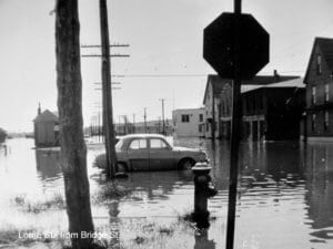
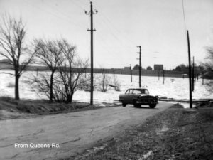
These risks are not new. In the late ‘60s there was a freshwater flood of the marshes and parts of the town. “I talked to a lady . . . and she was saying that she remembers paddling with her dad across Bridge Street in a boat to get drugs for her neighbour who needed them [for a medical condition],” said Lieske. “That was not long ago . . . but the locations are the same, the vulnerability is in these low points .”
How can we combat these kinds of challenges and risks of displacement and destruction due to flooding? Lieske advocates for combined outreach, communication and education. For example, Lorne Street (which is home to the Struts Gallery and the Kookie Kutter Bakery and leads to the Sackville train station) is chronically vulnerable due to its geographic and topographical position.
Ideally, Lorne Street would not be inhabited, according to Lieske.“[Lorne Street] should probably be just left to be . . . but that requires some creative thinking about reimagining these spaces and it takes time to rezone [and] relocate,” Lieske said. “The best kind of vulnerability reduction would be to have nobody in a flood risk zone, that would be ideal, but in the reality that might be too expensive or impractical to implement so you end up with a sliding scale continuum of solutions.”
Through raising awareness of the impacts of climate change on the small scale as well as the large, more practical potential solutions can be presented to combat these risks, potentially through rezoning as opposed to large-scale engineering changes.


